Research Scientist
Geophysics
North Eastern Space Applications Centre - Shillong,
Meghalaya
15,600 - 39,100 a
month
Advertisement No.
NESAC/01/2016
Research Scientist Hydrology Jobs recruitment in North
Eastern Space Applications Centre
Project : Flood Early Warning Systems (FLEWS)
Research Scientist
Hydrology / 01Post
Qualification: M.E/M.Tech (Water Resources/Hydrology) or
M.Tech/M.Sc Remote Sensing (Hydrology) or equivalent
Desired Credentials : Experience in Water
Resources/Hydrology area with working knowledge of HEC-HMS, FLO-2D, MIKE FLOOD,
SWAT, RS & GIS, etc.
Research Scientist
Meteorology/ 01 Post
Qualification : M.Sc/M.Tech in Physics /
Meteorology/Atmospheric Science/Earth Systems Science or equivalent .
Desired Credentials: Experience and conversant with LINUX operating
system and programming knowledge in MATLAB.
Project: Doppler Weather Radar (DWR),Cherrapunjee
Research Scientist
Electronics & Electrical Engineering/ 02 Posts
Qualification : M.Tech in Electronics/ Electronics and
Telecommunication Engineering/ Electronics design & Technology/Electrical
Engineering or equivalent.
Desired Credentials: Experience and conversant with LINUX
operating systems and programming knowledge in MATLAB.
Project: North Eastern Region Node for Disaster Risk
Reduction (NER-DRR)
Research Scientist
Information Technology /01 Post
Qualification : M.E/M.Tech in Computer Science/IT or
equivalent.
Desired Credentials: Experience and knowledge in Geoserver,
Mapserver, UML, XML, or open layers, Jquery and free/open source.
Research Scientist
Geophysics / 01 Post
Qualification : M.Sc/ M.Tech in Geology Geophysics or
equivalent .
Desired Credentials: 1) Experience in earthquake / landslide
related work. 2) Additional degree/diploma in relevant field. 3) Working
knowledge of GIS, Programming knowledge in MATLAB, IDL, FORTRAN, etc.
Research Scientist
Atmospheric Science /01 Post
Qualification : M.Sc in Physics/Atmospheric
Science/Meteorology or M.Tech in Earth System Science or equivalent.
Desired Credentials : 1) Experience in meteorology /
atmospheric science or relevant field. 2) Knowledge in LINUX OS, programming in
MATLAB, IDL, FORTRAN, etc.
Research Scientist
Environment /01Post
Qualification : M.Sc in Environmental
Sciences/Forestry/Ecology/Bo tany/Geography or equivalent. Desired Credentials:
Experience on air pollution/ climate change studies, etc. 2) Knowledge on Remote
Sensing and GIS programming.
Research Scientist RS
& GIS /02 Posts
Qualification : M.Sc/M.Tech in RS&GIS/ Geoinformatics
from a recognized university or equivalent.
Desired Credentials: Experience in microwave remote
sensing/photogrammetry / hyperspectral/LIDAR data analyst, etc.
Research
Scientist Communication Support /01Post
Qualification : M.E/M.Tech in Electronics &
Communication Engineering or equivalent.
Experience in satellite communication based system /
application projects.
Pay Scale: Rs.15600- 39100
Note: 1 Number of positions indicated above are provisional
and may vary depending on the actual requirement. 2 ME/M.Tech/MSc or its
equivalent degree should be in first class with an aggregate minimum of 65% or
CGPA/CPI grading of 6.5 on a 10 scale or equivalent. Rounding-off marks is not
allowed.
Age Limit: 35 years as on 09.09.2016 (40 years in case of
SC/ST candidates and 38 years for OBC candidates).
Pay & Allowances: Selected candidates will be offered
the fellowship as Research Scientist in the Pay Band of '15600-39100 with Grade
Pay ' 5400/-. The gross emoluments in the minimum of Pay Band will at present
be approximately ' 47250/-. In addition HRA at the prescribed rates in force at
the place of posting will be paid.
Selection Process: The qualifications prescribed in this
advertisement are the minimum requirement and the same does not automatically
make candidates eligible to be called for interview. Based on the experience
and details of marks furnished by the applicants, the candidates will be
shortlisted for interview..
-----------------------------------------------------------------------
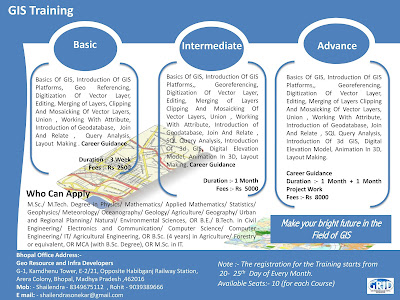
Note :- Short Term GIS and Remote Sensing Training in Available in Bhopal Madhya Pradesh..
For More details Please Visit us at www.gridindia.org