Showing posts with label GIS Expert Jobs. Show all posts

Tuesday, December 26, 2017

Scientist in State Forest Research Institute Jabalpur, Madhya Pradesh


Scientist
State Forest Research Institute Jabalpur - Jabalpur, Madhya Pradesh

State Forest Research Institute Jabalpur Jobs 2017: 04 Scientist Vacancy for Array Salary 39,100 published on 26th December 2017. On 26/12/2017,

State Forest Research Institute Jabalpur announced Job notification to hire candidates who completed Array for the position of Scientist. . Vacancy 1 : Scientist Qualification : Any Post Graduate,
M.Phil/Ph.D Vacancies : 04 posts

Salary : Rs. 15,600 - Rs. 39,100 Per Month

Experience : 5 - 7 years

Job Location : Jabalpur

Last Date to Apply : 28/02/2018

Essential Qualification & Desirable Qualification:

a. Animal Ecology and Conservation Biology Post - 01: Masters Degree in Forestry/ Wildlife Science/ Life Science/Environmental Science with minimum 60% marks from recognized university. Minimum five Years experience in the field of predator and prey monitoring. - Ph.D. in relevant field. Knowledge on modem advanced population monitoring & relevant software.

b. Landscape level Planning and Management Post - 01: Masters Degree in Forestry! Wildlife Science/ Life Science/Environmental Science with minimum 60% marks from recognized university. Minimum five years experience in the field of landscape ecology. Ph.D. in relevant field. Experience in landscape planning/ Remote Sensing and GIS.

c. PA Network, Wildlife Management and Conservation Education Post 01: Masters Degree in Forestry/Wildlife Science/ Veterinary Science!Life Science/Environmental Science with minimum 60% marks from recognized university. Minimum five years experience in the field of wildlife management. - Ph.D. in relevant field. Experience in wildlife handling and conservation education.

d. Remote Sensing and GIS (GIS Analyst) Post - 01: Masters Degree in Forestry/Wildlife Science/Life Science/Environmental Science/ Remote Sensing and GIS/Geo-informatics with minimum 60% marks from recognized university. Minimum five years experience in the field of Remote Sensing and GIS. - Ph.D. in relevant field. PG Diploma in Remote Sensing & GIS from recognized institute/university. Experience in advanced Remote Sensing and GIS software for wildlife monitoring.Address.

State Forest Research Institute Jabalpur, Bhim Nagar, Polipather, Jabalpur, Madhya Pradesh 482008 Selection Procedure : Selection Will be Based either Written Exam/Interview

How to Apply: Interested Candidates can apply on or before 28/2/2017

for more details please visit the following link :

http://mpsfri.org/files/SFRI_Advt_Application.pdf


---------------------------------------------------------------------------------------------------------------
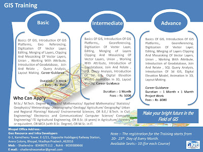
Note :- Short Term GIS and Remote Sensing Training in Available in Bhopal Madhya Pradesh..
-----------------------------------------------------------------------------------------------------------------------------------------------

Sunday, April 9, 2017

GIS and remote sensing Execuitives in ADCC Infocad Ltd.

3 to 5 Yrs in Hyderabad

Job Description
Proficiency with MapInfo/ArcGIS/AutoCAD etc.
Experience in creating GIS thematic layers related to Land Information System and Municipal GIS will be given preference and other spatial data related issues and opportunities. 

Experience with Microsoft Office Applications - Excel, Access, Word, Powerpoint etc.
Demonstrated experience using ESRI ArcGIS to develop, edit, and maintain spatial data from engineering as-built drawings.

Functional Area: Back Office Operations Industry: IT - Software Other Skills: Land Information System Word

 Recruiter details Company Name: ADCC Infocad Ltd.Company Description: 
ADCC Infocad incorporate in 1998 is a Meghe Group Company.
ADCC  incorporated in 1998, is a central India based Engineering and IT services company providing “Total Solution” in Geographical Information System (GIS), Photogrammetry, Engineering Design Services, Software Development and Energy System and Solutions in India and abroad.ADCC  caters to the GIS and Engineering industry and has emerged as Global Premier Software Solution Provider through its Alliances with World Leaders like Autodesk Inc. USA world’s biggest Design Content company, MathWorks, Dassault Systemes, Intergraph,  Siemens, Digital Globe,  Adobe, Corel, Sanako, Microsoft, HP & Tally.
 ADCC has been recently appointed as PAN INDIA Distributor/Reseller for Trimble-Building Construction Division for Education business..ADCCAcademy is the training Arm of ADCC for knowledge sharing in the fields of GIS, Remote Sensing and  Engineering & Design Software.  Besides  Academy also imparts various soft skill trainings in collaboration with DCTI, Mumbai and preparing students for various competitive exams.ADCC has emerged as Partner-of-Choice for leading Indian companies and Government sector.  Our project teams seamlessly integrate into our client project development team and environment and act as a virtual extension of their GIS and Engineering enterprise solutionsBased in Nagpur with branch offices in Mumbai, Pune, Hyderabad,  Ahmedabad, Lucknow and overseas offices in Africa-  Nairobi (Kenya) and|  Accra (Ghana)the company boasts the  state of  art infrastructure in Nagpur admeasuring 15,000 sq ft  with ultra modern IT Systems for Data Security and Integrity.ADCC is  CRISIL rated and NASSCOM & ASSOCHAM registered IT/ITES company.ADCC is empanelled with various Govt. Bodies for providing Services & Software Solutions. A MOU has been signed as GIS Technology Partner with Regional Center of Mapping of Resources for Development (RCMRD), Kenya, which is an inter-governmental organization and currently has 18 contracting Member States in the Eastern and Southern Africa Regions.AI Instruments Pvt. Ltd. it's a part of Meghe Group. Meghe group is a conglomerate, which has varied interests in the fields of Basic and Professional Education, Training, Hospitals, Industries & Estates, Banking, Information Technology, Media & Entertainment etc. based out of Nagpur for last three decades.

 Email: nilesh.d@adccinfocad.com

Telephone: 7123014305

--------------------------------------------------------------------------------------------------------------
Note :- Short Term GIS and Remote Sensing Training in Available in Bhopal Madhya Pradesh..
-----------------------------------------------------------------------------------------------------------------------------------------------


Monday, July 25, 2016

Telecommunication and Electronics Trigent Software Limited - Mumbai, Maharashtra

Telecommunication and Electronics 

Trigent Software Limited  - Mumbai, Maharashtra

₹2,00,000 - ₹3,00,000 a year

No. of Job opening               1

Functional Area Other 

Industry Type IT-Software/Software Services
Keywords Networking, Telecom, Telecommunication, Electronics, GIS, GPS, Network Design
Freshers -1 year experience in telecommunication and electronics.

Work profile is basically GIS , Network design .

Knowledge of Telecom Infrastructure / Electrical Infrastructure / Network Topology / GPS data.

Good communication is must.

Desired Candidate Profile Profile Description
NA

Under Graduate Qualification

PG Qualifications Any PG Course (Any Specialization)

*Note: Candidate should have either UG or PG qualifications

---------------------------------------------------------------------------------------
Note :- Short Term GIS and Remote Sensing Training in Available in Bhopal Madhya Pradesh..


GIS Digitization Engineer Quantum Asia Pvt Ltd. - Jaipur, Rajasthan

GIS Digitization Engineer 

Quantum Asia Pvt Ltd. - Jaipur, Rajasthan
Experience in GIS data handling/ Digitization tools like Arc Info, Arc Editor, ArcView, Auto CAD, MapInfo etc. Exposure to Digital Image Interpretation and spatial data conversion
Graduate in Maths, Science, Geography, Geology, Environmental Science or Computer Applications/ Diploma in Engineering.
Experience Required: 1-3 Years.
Job Type: Full-time
Job Location:
  • Jaipur, Rajasthan
Required education:
  • Bachelor's
Required experience:
  • GIS: 3 years

==============================================
Note :- Short Term GIS and Remote Sensing Training in Available in Bhopal Madhya Pradesh..


Tuesday, June 21, 2016

Project Associate/ Project Assistant Andhra University Visakhapatnam, Andhra Pradesh

Project Associate/ Project Assistant 
Andhra University Visakhapatnam, Andhra Pradesh

Project Associate/ Project Assistant

Job vacancies in Andhra University on a purely temporary basis

Project Associate 

Qualification with M.Tech First Class (9.00 CGPA) in Remote Sensing/Geoinformaties (preference will be given to those who have previous experience in handling In SAR data sets)

Project Assistant 

Qualification with B.Tech First Class (9.00 CGPA) in civil Engineering with experience in GPS data handling.

----------------------------------------------------------------------------------------------


Note :- Short Term GIS and Remote Sensing Training in Available in Bhopal Madhya Pradesh..

Tuesday, June 14, 2016

JRF Geology NRSC- Hyderabad, Andhra Pradesh

JRF Geology
NRSC- Hyderabad, Andhra Pradesh

Salary - 25,000 a month

Advt No.NRSC/RMT/5/2016 19.05.2016

JRF Geology recruitment in National Remote Sensing Centre (NRSC-ISRO)

Post Code : I
Qualification : ME/M.Tech/M.Sc.(Tech) in Geology / Geophysics / Remote Sensing after B.E / B.Tech / M.Sc. (OR) M.Sc in Geology / Remote Sensing & GIS with NET or equivalent qualification
No. of Post : 01

Post Code : II
Qualification : M.E / M.Tech in Meteorology / Climatology / Atmospheric Sciences / Remote Sensing after B.E. / B.Tech. / M.Sc. (OR) M.Sc. in Physics/ Meteorology/ Climatology / Atmospheric Sciences / Remote Sensing & GIS with NET or equivalent qualification
No. of Post : 01

Post Code : III
Qualification : M.Sc. (Agriculture) in Soil Science/Agricultural Chemistry & Soil Science/Agronomy(with Soil Science as a subject) with ICAR-NET or equivalent qualification (OR) ME/M.Tech in Remote Sensing & GIS/ Geo-Informatics. Desirable Qualification: Working knowledge in Soil sampling and Analysis / spatial data analysis.
No. of Post : 01

Post Code : IV
Qualification : ME/M.Tech in Remote Sensing / Remote Sensing & GIS /Geo-Informatics and Remote Sensing / Geoinformatics. Desirable Qualification: Knowledge in programming languages such as MATLAB, Python, Open CV and CNL etc, Satellite Image Analysis, Interpretation and GIS.
No. of Post : 03

Post Code : V
Qualification : M.E. / M.Tech in Meteorology/ Atmospheric Sciences / Remote Sensing & GIS after B.E. / B. Tech / MSc (Or) (a) M.Sc in Physics/ Meteorology/ Atmospheric Sciences with NET or Equivalent. & (b) M.Sc degree holders must have studied Mathematics & Chemistry at graduation level. Desirable Qualification: Computer programming skills in Fortran / C or any high level language and Aptitude for working in Atmospheric Sciences.
No. of Post : 02

Post Code : VI
Qualification : ME/M.Tech in Geomatics / Geoinformatics after BE/B.Tech in Civil / Computer Science/Electronics. Desirable Qualification: Skills in C/C++, Java and Python programming languages
No. of Post : 01

Post Code : VII
Qualification : M.Sc. (Agriculture) in Agricultural Chemistry & Soil Science / Agronomy (with soil science as a subject) with ICAR-NET/equivalent qualification. Desirable Qualification: Knowledge in Soil Analysis / Geoinformatics / Spatial data analysis.
No. of Post : 01

Post Code : VIII
Qualification : M.E. / M.Tech in Water Resources / Hydrology / Environmental Engineering after B.E. / B.Tech in Civil / Environmental Engineering.
No. of Post : 01

Post Code : IX
Qualification : M.E. / M.Tech in Water Resources / Hydrology / Hydraulics Engineering after B.E. / B.Tech in Civil / Environmental Engineering
No. of Post : 02

Post Code : X
Qualification : ME/M.Tech in Remote Sensing / Geoinformatics / Environmental Geoinformatics after B.Sc (Agriculture) /B.Tech in Agriculture / Civil Engineering / M.Sc in Agriculture/Physics.
No. of Post : 01

Place of Posting : For Post Nos: I, II & III shall be at Jodhpur and for Post No: VII at Nagpur. For the balance posts the place of posting is Hyderabad. The JRFs posted at Hyderabad shall also be liable to serve at NRSC Earth Station, Shadnagar campus, Mahabubnagar Dt. if a need arises. The selected candidates shall also be liable to be posted anywhere in India based on project requirements.

Emoluments : Consolidated pay of Rs.25,000/- plus applicable HRA thereon if hostel facility is not provided at the station. The present rates of HRA is 30% for Hyderabad and 20% for Jodhpur & Nagpur.

Age Limit : Maximum Age Limit of 28 years

Selection Process : Being Posts assigned for conducting and guiding research, selection shall be 100% by Merit. Candidates shortlisted based on % of marks shall be called for Interview at Hyderabad tentatively scheduled in June, 2016. Call letters for Interview shall be sent by e-mail to short-listed candidates. The list of short-listed / finally selected candidates shall be hosted at NRSC website. Interview : Candidates called for Interview shall be reimbursed to and fro Sleeper Class train fare by the shortest route against submission of a copy of train ticket / e-ticket print-out. Candidates should submit for verification all Original certificates in proof of Educational Qualification (Class X onwards) along with one set of self-attested photocopies. Semester/year-wise mark-sheets should also be produced apart from Consolidated Mark Sheets and Provisional/Final Degree Certificates.


-----------------------------------------------------------------------------

Note :- Short Term GIS and Remote Sensing Training in Available in Bhopal Madhya Pradesh..

Thursday, June 9, 2016

AutoCAD Operator SKP Projects Pvt. Ltd. - Vadodara Makarpura, Gujarat

AutoCAD Operator 

SKP Projects Pvt. Ltd. - Vadodara Makarpura, Gujarat

Download, convert and upload GIS data available in existing GIS data
Testing & validation of existing GIS map data with as built drawings (Auto cad Drawings) & Google map
Inserting additional data in excels with respect to GIS object ID
Collecting & Validating GIS data from field engineers in form of auto cad files/ Microsoft excel
Identifying and correcting errors or omissions in the data
Perform GIS data quality testing, including reviewing data for completeness and accuracy
Testing & validation of existing GIS map data with as built drawings (Auto cad Drawings)
Communicate with the team to understand technical specifications of the Pipeline assets
Pipe assets mapping in GIS
Candidate should possess an understanding of land survey, topographical drawings, Longitudinal Section & Cross section
Key Skills : AutoCad Civil 3D (Latest Version), Google Earth, Microsoft Office, Global Mapper

Job Type: Full-time


Note :- Please review all application instructions before applying to SKP Projects Pvt. Ltd..

----------------------------------------------------------------------------------------------------

Note :- Short Term GIS and Remote Sensing Training in Available in Bhopal Madhya Pradesh..

JRF Geography Central University of Karnataka - Gulbarga, Karnataka


JRF Geography 


Central University of Karnataka - Gulbarga, Karnataka


No. CUK/ADMN-III/F-834/2016-17/

JRF Geography Jobs opportunity in Central University of Karnataka on contract and temporary Basis

Project Title : Mitigating and Managing Urban Heat islands through Social Forestry Using Hyper & MultiSpectral Remote Sensing

No. of Posts : 02 (OBC-1 & SC-1)

Qualifications : M.E/M.Tech in Remote Sensing / GIS / Geoinformatics OR M.Sc. in Remote sensing / GLS Geoinformatics / Geography with valid GATE/ NET Score. Desirable: Good working knowledge of different GIS, remote sensing and statistical softwares, Good programming skills in IDL / Matlab / Python, Good oral and written communication skills, willingness to participate in extensive field visits.

Stipend: Rs.25,000

Duration of the project: 3 years

----------------------------------------------------------------------------------------------

Note :- Short Term GIS and Remote Sensing Training in Available in Bhopal Madhya Pradesh..

GIS Expert Weather Risk Management Services - New Delhi, Delhi

GIS Expert 
Weather Risk Management Services - New Delhi, Delhi

Should have sound knowledge of GIS and Remote Sensing
-Data Capturing from multiple sources e.g. scanned images, Satellite imageries or Aerial photograph
-Preferably having knowledge and experience in optical and microwave data
-Hand on experience in GIS based tools and applications
-Support the development of an in-house global exposure management system
-Assist in developing spatial analysis tools to measure risk to insurance exposure
-Work with underwriters, and management to define new innovative tools to support risk management initiatives

Salary 
As per Industry Standards

Role 
Analytics & BI, Data Analyst

If interested, post your resume at career@weather-risk.com with

Relevant Experience, 
Expertise, 
Current Company & Designation, 
Current & Expected CTC , 
Reason to Relocate
Notice Period.

Please review all application instructions before applying to Weather Risk Management Services.

----------------------------------------------------------------------------------------------

Note :- Short Term GIS and Remote Sensing Training in Available in Bhopal Madhya Pradesh..